


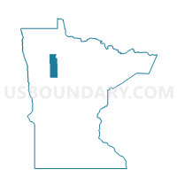
Sinclair Twp. Voting District, Clearwater County, Minnesota
About
Outline

Summary
| Unique Area Identifier | 601575 |
| Name | Sinclair Twp. Voting District |
| County | Clearwater County |
| State | Minnesota |
| Area (square miles) | 36.29 |
| Land Area (square miles) | 34.56 |
| Water Area (square miles) | 1.72 |
| % of Land Area | 95.25 |
| % of Water Area | 4.75 |
| Latitude of the Internal Point | 47.70027810 |
| Longtitude of the Internal Point | -95.25166290 |
Maps


Graphs
Select a template below for downloading or customizing gragh for Sinclair Twp. Voting District, Clearwater County, Minnesota


Neighbors
Neighoring Voting District (by Name) Neighboring Voting District on the Map
- Alaska Twp. Voting District, Beltrami County, MN
- Clover Twp. Voting District, Clearwater County, MN
- Dudley Twp. Voting District, Clearwater County, MN
- Greenwood Twp. Voting District, Clearwater County, MN
- Holst Twp. Voting District, Clearwater County, MN
- Leon Twp. Voting District, Clearwater County, MN
- Roosevelt Twp. Voting District, Beltrami County, MN
Top 10 Neighboring County Subdivision (by Population) Neighboring County Subdivision on the Map
- Dudley township, Clearwater County, MN (400)
- Holst township, Clearwater County, MN (369)
- Leon township, Clearwater County, MN (345)
- Roosevelt township, Beltrami County, MN (225)
- Alaska township, Beltrami County, MN (217)
- Sinclair township, Clearwater County, MN (164)
- Clover township, Clearwater County, MN (113)
- Greenwood township, Clearwater County, MN (83)